14-11-2025
The F249 road in Iceland, also known as Thorsmerkurvegur, is one of the country’s most thrilling and adventurous mountain routes. Stretching about 32 kilometers from the Ring Road to the Thorsmork Nature Reserve, traveling along this unique road allows you to experience Iceland’s wild interior region, complete with glaciers, volcanic valleys and challenging river crossings.
An Icelandic route that’s not for the faint-hearted, traversing the F249 road requires a specialized vehicle and experienced driver. We’ll guide you through all you need to know about Iceland’s F249 route in this article, so you’re fully prepared for the adventure of a lifetime!
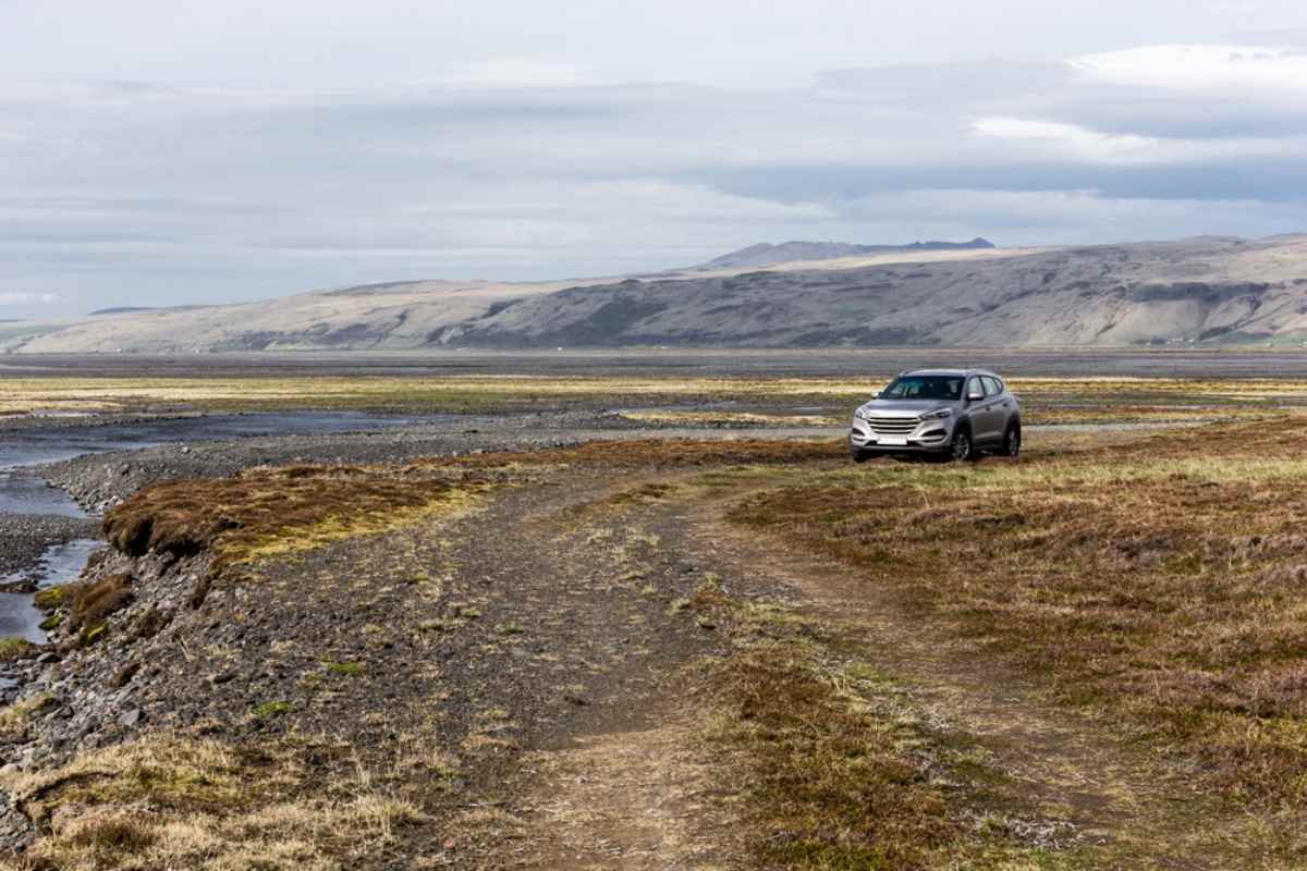
The F249 road in Iceland is one of Iceland’s F-roads, which means it’s an unpaved, gravel road in the mountains accessible only by 4x4 vehicles. The 'F' stands for Fjallvegur, or mountain road, signifying that this route traverses Iceland’s rugged Highlands.
Marked on maps as F249, it splits from the paved Route 249 and transforms into gravel and dirt once it enters the wild terrain leading toward Thorsmork. Reaching Thorsmork via the F249 is not a casual drive. It’s an expedition! The route includes several water crossings and steep, rocky patches, leading to stunning views of glaciers, volcanoes and Iceland’s dramatic wilderness.

So, where exactly is the F249 road in Iceland? Well, the F249 route sits in the south of the island, beginning east of the famous Seljalandsfoss waterfall on Iceland’s southern coast. This area is easily accessible from the Ring Road (Route 1), making it a practical yet daring detour for travelers venturing into Iceland’s Highlands.
The road winds deep into the Thorsmork Valley, nestled between three glaciers: Eyjafjallajokull, Tindfjallajokull and Myrdalsjokull. As it ascends through river valleys and glacial plains, the F249 ends at Thorsmork’s Nature Reserve, a lush destination that contrasts sharply with the barren volcanic landscapes en route.
Driving the F249 road in Iceland is not just about reaching a destination; it’s about the remarkable landmarks along the way. The stretch of road that is the F249 offers scenic hiking routes and incredible panoramas. It’s truly the ‘Land of Ice and Fire’ in all its glory! Here are some of the top places to visit along the F249:
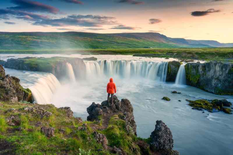
The journey along the F249 begins near Seljalandsfoss, one of Iceland’s most photographed waterfalls. Falling from old sea cliffs that once marked the country’s ancient coastline, this famous Icelandic waterfall is powered by glacial melt from Eyjafjallajokull. Here, you can walk behind the 60-meter cascade on a path that circles behind the curtain of water, offering a rare perspective few waterfalls in the world can match. During the summer, you can often see rainbows in the waterfall’s spray!
Nearby, Gljufrabui Waterfall sits just a few minutes’ walk north of Seljalandsfoss, partially enclosed by a canyon wall that requires you to wade through a shallow stream to find it.

Often called Iceland’s hidden waterfall, Gljufrabui drops around 40 meters from the Gljufura River into a secluded pool, creating a misty chamber surrounded by moss-covered basalt cliffs. The waterfall’s name translates to ‘Canyon Dweller’, an apt description for a waterfall hidden deep within its cliffside home. Unlike its more dramatic neighbor Seljalandsfoss, Gljufrabui feels quiet and secretive, a true hidden gem!
Shortly after visiting these two spectacular waterfalls, you can stop at Nauthusagil Ravine, a narrow gorge framed by canyon walls. An unmissable stop along the F249 road in Iceland, this gorge feels almost prehistoric with its lush greenery and echoing trickle of water. Wooden steps, rocks, and ropes help explorers navigate through the stream that flows down the middle, while the deeper you venture, the darker and narrower the space becomes until a hidden waterfall comes into view. Beautiful! Don’t forget to bring your waterproofs for this adventure.
Further along Iceland’s F249 road, the Gigjokull Glacier, an outlet of Eyjafjallajokull, dominates the scenery. This glacier once flowed smoothly into a lagoon, but the 2010 eruption of Eyjafjallajokull (remember all the air travel disruption across Europe?!) caused massive floods of melted ice and volcanic debris that forever changed the valley.
Today, the area is full of twisted rock formations, dark ash layers, and scattered ice remnants. The glacier shimmers in shades of silver, blue, and black, making it one of the most visually striking places in South Iceland. A short walk leads to a glacial lagoon filled with floating ice chunks, a haunting reminder of both the beauty and volatility of Iceland’s natural world.

Among the route’s most notable features is the Krossa River, a serene waterway surrounded by lush, green mountains. This stunning river is not just to be admired for its beauty; part of the F249 actually crosses the Krossa River. A deep and unpredictable crossing, its depth and current change daily depending on rainfall and glacial melt, sometimes rendering the crossing completely impassable even for large super jeeps. Inexperienced drivers should not attempt to cross it; instead, park before the river and hike or use transfer vehicles to Thorsmork. For those stopping before the river, the view itself is worth the trip.
The F249 road culminates at the spectacular Thorsmork Nature Reserve, named after the Norse god Thor. Hidden between glaciers, this valley is an oasis of green birch forests, black sands, and flowing rivers. The unique microclimate allows for more vegetation than most of Iceland’s Highlands, creating a landscape that feels almost otherworldly after the kilometers of barren volcanic terrain.
Thorsmork is a paradise for hikers, with a network of trails ranging from gentle forest walks to challenging climbs with sweeping panoramic views. This area serves as the finish point of famous routes such as the Fimmvorduhals trail from Skogar and the Laugavegur trek to Landmannalaugar. Thorsmork is often described as one of the most peaceful and beautiful places in Iceland, a fitting reward at the end of the demanding F249 road.

Once in Thorsmork, the hike to Valahnukur Mountain offers an incredible vantage point over glaciers, lava fields, and braided rivers (criss-crossing networks of rivers). The trail climbs steeply through dark volcanic earth before opening onto a ridge where every direction seems more breathtaking than the last. Looking south, you’ll see the white cap of Eyjafjallajokull, and to the north lies the intricate valley system of Thorsmork and the twisting glacial rivers below. Watching the clouds drift around mountain peaks while the rivers glint below really gives you a sense of awe at the scale and wildness that define Iceland.
A 4x4 vehicle is legally required to travel on any of Iceland’s F-roads, including the F249, so you’ll need to make sure to choose a high-quality and reliable 4x4 car rental in Iceland. It’s also super important to check that your rental contract allows F-road travel.
Keep in mind that even if you have F-road insurance, damage from water crossings is never covered. If you’re unsure about anything to do with vehicle type or rental insurance in Iceland, we recommend asking your rental agency, as they can best advise you on safety requirements and recommended coverage for your planned route.
As we’re sure you’ve gathered by now, the F249 road demands preparedness and respect. Here are some top safety tips to keep in mind for traveling this route:
Be aware that river crossing conditions can change – River crossings can vary daily, with the Krossa River, in particular, rising suddenly after rainfall or snowmelt.
Check road and weather conditions – Always check the Iceland weather forecast and Iceland road conditions before setting out.
Bring essential gear – Make sure you’re prepared for your trip along the F249 road in Iceland by bringing a map, food and drink supplies, and recovery gear.
Stick to marked routes – Stay strictly on marked roads, as off-road driving is illegal and harms fragile volcanic ecosystems.
Consider a guided group tour – Note that if you prefer not to drive the F249 road in Iceland yourself, you can reach Thorsmork using seasonal Highland buses or guided super jeep tours departing from Seljalandsfoss or Hvolsvollur.

The F249 road is open only during summer, typically from late June to early September, when melting snow and calmer conditions make the route safer. Outside this period, the road is closed by law due to dangerous conditions, including impassable rivers and deep snow. Even during summer, you should confirm that the road is open and safe before departure, as even short rainstorms can turn safe crossings into serious hazards within hours.
Driving the F249 road in Iceland is one of the country’s most memorable adventures. This route demands courage and preparation but rewards you with a unique journey into the depths of Iceland’s wilderness that few others experience. Whether driven behind the wheel of a 4x4 or explored on a guided super jeep tour, the F249 road captures the essence of Iceland’s wild beauty: rivers, glaciers, volcanoes and the unforgettable valley of Thorsmork at the end of the road.
F249 Iceland is also a paradise for photographers and nature enthusiasts. With every kilometer, the landscape shifts: from meadows and rivers, to ash plains, glacial tongues and mountain ridges. The changing light turns volcanic slopes deep red and glaciers pale blue as the sun moves through the day. Top photography tip: Early morning drives offer the best lighting for photography.
Inspired to explore Iceland on your own unique vacation? Get set for your once-in-a-lifetime trip by selecting your own rental car in Iceland to explore our beautiful island. Got any questions? Don’t hesitate to contact our friendly team and we’ll be super happy to help you. Prepare for magical landscapes and incredible outdoor adventures!
Discover the top 20 waterfalls in Iceland to visit, including the famous Gullfoss, Skogafoss, Seljalandsfoss, Svartifoss...
Read More
Discover why fall in Iceland is unmissable with our guide. See autumn colors, Northern Lights & more. Click to read ...
Read More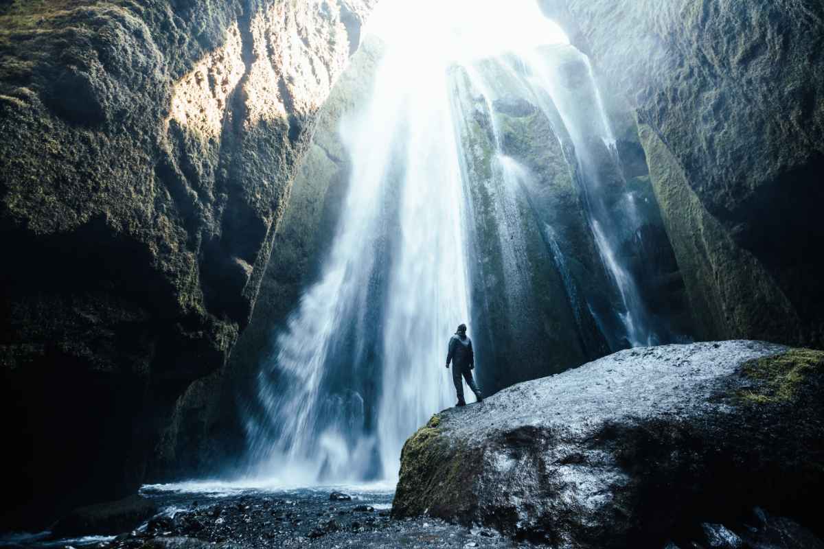
Discover Iceland's waterfalls, a mesmerizing collection of natural wonders! Read about the best waterfalls to visit and ...
Read More